


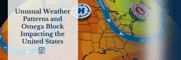
The United States is currently experiencing a dominant weather pattern known as an omega block, which is causing significant weather changes across the country. This unique weather phenomenon brings an unexpected thunderstorm threat to California, intense heat to the Northwest and Northern Plains, and relatively cooler conditions to certain parts of New England during June.
The omega block occurs when the jet stream takes on the shape of the Greek letter omega, with two southward plunges associated with low-pressure systems in California and the Northeast. Between these plunges, a ridge of high pressure forms, creating a northward bulge in the jet stream that extends from the Northern Plains and Northwest into Canada.
Meteorologists often teach about blocking patterns, and the omega block is one of them. Other similar patterns include the Greenland block and the rex block. These patterns exhibit an elongated alignment of the jet stream from north to south, causing weather systems to move slowly and become “blocked.” Consequently, weather patterns fail to progress steadily from west to east as they normally would.
Although blocking patterns come and go, the United States has been experiencing various forms of blocking since May, resulting in unusual weather conditions. Specifically, California is facing an atypical June thunderstorm threat due to sufficient moisture and the presence of an upper low-pressure system. Showers and thunderstorms are expected throughout the state, with the highest likelihood of rain and localized flash flooding occurring in elevated areas like the Sierra Nevada. However, even lower elevations might experience isolated storms.
The Rockies and Plains regions will also experience thunderstorm activity due to disturbances caused by the upper low-pressure system near California. These disturbances will trigger showers and storms throughout the week, with the possibility of heavy rainfall leading to localized flash flooding.
The omega block will create a temperature divide across the country. The Northwest and Northern Plains will endure persistently high temperatures as a result of the upper-level ridge of high pressure. For instance, Portland, Oregon, will experience temperatures in the low 80s and 90s, several degrees above its average high of 73 degrees.
Conversely, the Northeast, particularly New England, will encounter temperatures near or slightly cooler than the early June average. For example, Boston will remain in the 60s on Wednesday and Thursday, compared to its average high of approximately 74 degrees.
Furthermore, the upper-level low-pressure system over the Northeast will continue to transport wildfire smoke from Canada into the Eastern region, affecting air quality. The latest updates on smoke and air quality concerns can be found here.
Chris Dolce, a senior meteorologist with weather.com, has been reporting on weather news for over 10 years, starting with The Weather Channel in the early 2000s.
The Weather Company’s main objective is to provide journalism that focuses on breaking weather news, the environment, and the importance of science in our daily lives. The views expressed in this article may not necessarily reflect the position of our parent company, IBM.